
International maritime boundary disputes involving overlapping exclusive economic zone or continental shelf claims are resolved by agreement under international law, with the aim of reaching an equitable solution under the United Nations Convention on the Law of the Sea. If states cannot agree, the Convention provides procedures for resolving disputes, subject to its provisions and exceptions. Cooperation can also help manage shared waters while boundary questions remain unresolved.
It is understandable to see a formal boundary agreement as the first step towards practical progress. But states can sometimes coordinate resource activity before settling a boundary. This article explains how legal expertise and historical records inform maritime delimitation, how UNCLOS procedures work, and how cooperation can reduce tension and support practical arrangements in disputed areas. It also explains why the choice of process and the evidence behind each claim can shape what happens next.
Key Takeaways
- Historical records and state conduct can inform maritime claims, but their legal significance depends on the dispute and the principles applied.
- UNCLOS provides routes for resolving overlapping claims, including agreement between states and formal dispute-settlement procedures.
- Cooperation on resource activity can help states manage a disputed area without first settling the boundary.
- Comparing disputes involving countries such as Indonesia and Malaysia can show how diplomatic engagement and legal processes interact.
- When a maritime claim affects your operations or assets, marine law advice can help you assess the legal and strategic issues.
State expertise and historical records in maritime delimitation
The term international maritime boundary disputes describes disagreements between neighbouring states about where maritime zones begin and end. Coastal geography, islands, baselines, historical records, resource interests and political priorities can shape those disagreements. A map alone rarely resolves competing claims. Legal analysis tests the evidence against geography and the principles of international law.
In international maritime boundary disputes, state expertise matters when applying those principles. Specialists compare nautical charts, legislation, diplomatic records and evidence of state conduct, then assess how each relates to the legal issues. The 1982 United Nations Convention on the Law of the Sea provides the central framework for modern maritime entitlements. Earlier decisions can also inform how later disputes are assessed.
The North Sea Continental Shelf cases explicitly introduced equity into maritime delimitation. Equity means seeking a fair result under the applicable legal framework, not simply dividing waters equally. In the Black Sea case, the International Court of Justice found no particular role for the state activities invoked as maritime effectivités. These international maritime boundary disputes show why evidence of state conduct requires careful legal assessment.
Historical evidence can still matter. In Maritime Dispute (Peru v Chile), the International Court of Justice found that an existing maritime boundary extended 80 nautical miles before delimiting its remaining course. The decision illustrates a useful analytical step: identify whether an earlier boundary arrangement exists, then establish what remains unresolved. The weight of historical records depends on the legal question they help answer.
What are the main causes of maritime boundary disputes? Common causes include overlapping maritime entitlements, differing interpretations of coastal geography, contested islands, and competing resource or security interests. The South China Sea illustrates how claims concerning maritime features and surrounding waters can intersect with strategic priorities.
What are the most significant maritime boundary disputes in the Indo-Pacific? The South China Sea dispute involving the Philippines and China is a prominent example, as is the Ambalat dispute between Indonesia and Malaysia. These cases show how legal claims, diplomacy and regional relationships can intersect.
ASEAN provides a regional setting for these issues, while international law offers a framework for defining and resolving claims. All ASEAN states and Timor-Leste are parties to UNCLOS, except Cambodia; Cambodia’s National Assembly voted in favour of ratification in 2019. Regional dialogue supports engagement, but does not itself determine a maritime boundary.
What are the economic and security impacts of maritime boundary disputes? Uncertainty can complicate resource activity, investment and enforcement, while competing claims can increase diplomatic or security tensions. Clearer arrangements can help states manage these practical risks, even before every issue is settled.
What are recent developments in major international maritime boundary disputes? In the Somalia v Kenya case, the International Court of Justice’s preliminary measures were dated 2 February 2017. That procedural milestone shows how a dispute can proceed through formal legal processes while the underlying boundary question remains contested.
UNCLOS procedures for resolving overlapping maritime entitlements
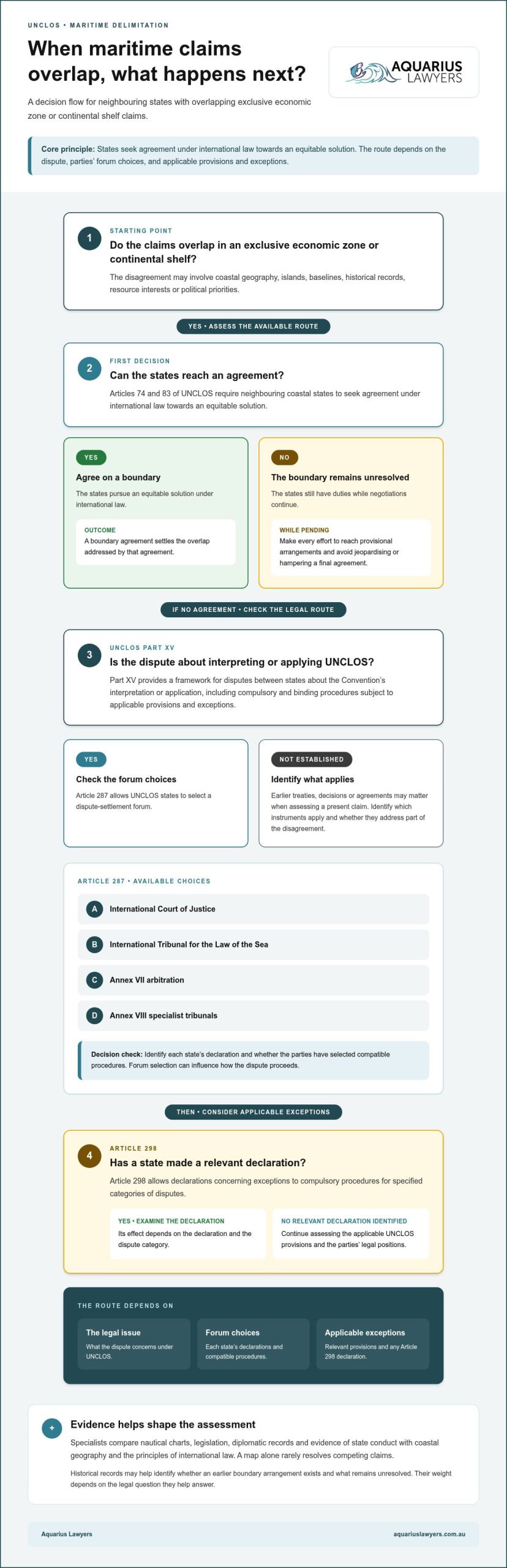
UNCLOS combines duties to negotiate with formal procedures for disputes about the Convention’s interpretation or application. The route available depends on the legal issue, the parties’ forum choices and applicable exceptions.
Dispute Settlement Before UNCLOS
Before UNCLOS, states could negotiate or pursue international adjudication, with the International Court of Justice drawing partly on the 1958 Geneva Conventions on the Law of the Sea. Earlier treaties and decisions may therefore matter when assessing a present claim. For you, the practical task is to identify which instruments apply and whether an existing agreement or ruling addresses part of the disagreement.
Part XV Dispute Resolution
Part XV of UNCLOS establishes a framework for resolving disputes between states about interpreting or applying the Convention, according to the United Nations. It provides for compulsory and binding procedures, subject to applicable provisions and exceptions. This means a state may have a formal route beyond continued negotiations, but the subject of the dispute and each party’s legal position affect which procedure applies.
Articles 74 and 83 address overlapping exclusive economic zone and continental shelf entitlements. They require neighbouring coastal states to seek agreement under international law towards an equitable solution. Pending agreement, the states must make every effort to reach provisional arrangements and avoid jeopardising or hampering a final agreement. This gives negotiations a practical focus: manage the overlap while preserving the possibility of a later settlement.
Article 287 allows UNCLOS states to select a dispute-settlement forum. The available choices include the International Court of Justice, the International Tribunal for the Law of the Sea, Annex VII arbitration and Annex VIII specialist tribunals. Forum selection can influence how a dispute proceeds, so you need to identify each state’s declaration and whether the parties have selected compatible procedures.
Article 298 allows declarations concerning exceptions to compulsory procedures for specified categories of disputes. The effect depends on the declaration and the dispute’s subject. A forum assessment therefore requires more than naming an institution: examine the claim, both states’ declarations and the relevant UNCLOS provisions before determining which process is available.
The International Court of Justice Statute also identifies the materials used in legal decisions. Under Article 38, these include international conventions, international custom and general principles of law, with judicial decisions and legal scholarship serving as subsidiary means. Article 38(2) permits the Court to decide ex aequo et bono only with the parties’ explicit agreement. These provisions help distinguish legal reasoning from a decision based solely on political compromise.
Inter-State cooperation in disputed maritime areas
States can separate practical management from final boundary delimitation. In the East China Sea, a joint development regime has been proposed to coordinate resource exploration and exploitation before states settle their maritime boundary. This approach treats cooperation as a working arrangement, not a ruling on sovereignty or a substitute for legal settlement.
For governments, this distinction matters. A shared management arrangement can focus on specific activities in defined maritime areas while leaving competing claims unresolved. Joint development has been recommended in the East China Sea and the Aegean. Clear terms can reduce uncertainty about which activities are coordinated, how each state participates and whether the arrangement affects either state’s legal position.
Cooperation needs practical boundaries of its own. States can identify the relevant area, specify the activities covered and establish how they will communicate. They can also record that participation does not decide the underlying boundary. These steps do not settle competing claims, but can make an interim arrangement more workable. The legal and political principles behind each state’s position still matter.
Indonesia’s agreements offer a regional example of negotiated delimitation: it has concluded maritime delimitation agreements with seven maritime neighbours. Such agreements can provide a more stable basis for managing shared maritime interests than an unresolved overlap. Each arrangement reflects the states involved, so one agreement does not automatically determine suitable terms for another area.
Vietnam’s experience also shows how regional engagement can progress over time. Vietnam became an ASEAN member in 1995 and made significant progress delimiting its maritime areas from the mid-1990s onwards. This is not a formula that every neighbouring state can copy. It does illustrate how sustained engagement and bilateral arrangements can advance delimitation alongside regional participation.
How are maritime boundary disputes affecting Australia and its neighbours? Overlapping claims can complicate decisions about resource activity, maritime enforcement and regional cooperation. The practical effects for Australia and neighbouring states depend on where the claims lie and which activities are involved.
Cooperation can reduce the risk that boundary disagreements obstruct every practical discussion. In the East China Sea, a joint development proposal focuses on coordinating resource activity before delimitation is complete. This requires careful attention to each state’s claims and the arrangement’s scope. It can provide a practical way to manage shared interests while governments continue to pursue a stable legal outcome.
Which countries are currently involved in major maritime boundary disputes?
There is no single reliable list that treats every maritime disagreement as an active boundary dispute. A case may concern sovereignty over a feature, overlapping maritime entitlements or a boundary already submitted for decision. To understand which countries remain involved, first identify the parties, the legal question and whether a binding settlement has addressed it.
Bangladesh and India provide a clear example of a formal boundary proceeding with a recorded outcome. The Permanent Court of Arbitration issued its final award in their Bay of Bengal maritime boundary arbitration on 7th July 2014. That means the arbitration itself is a concluded proceeding, rather than evidence that the same boundary dispute remains unresolved. The distinction matters when you assess current claims.
For a state-by-state assessment, distinguish four stages: competing claims, negotiations, formal proceedings, and an agreed or adjudicated boundary. A country may still have maritime disagreements elsewhere after resolving one boundary. Similarly, a case involving a maritime feature may concern sovereignty rather than delimitation. These distinctions help prevent a past case from being presented as a current dispute.
Review the legal record before relying on a headline or map. Identify whether the parties have signed an agreement, received an award or judgment, or continue to assert overlapping claims. Then check what the decision actually settled. A ruling on a specific boundary does not necessarily determine every maritime entitlement or political disagreement between the states involved.
The Bangladesh-India arbitration also shows why the nature of a proceeding matters. The Permanent Court of Arbitration issued a final award, providing a formal legal outcome for the parties’ dispute. When assessing another country pairing, ask whether the same parties remain in disagreement, whether the issue concerns a defined maritime boundary, and whether a later agreement or decision changed its status.
International cases can involve more than one legal issue. A disagreement about sovereignty over a maritime feature may affect claims to surrounding waters, but it is not the same as a request to delimit a boundary. Read the stated subject of each proceeding carefully. The country names alone do not show whether a case concerns territorial sovereignty, maritime limits or resource rights.
For businesses operating across borders, assess the specific area and legal issue rather than relying on a broad label such as “disputed waters”. Confirm which states assert claims, which legal process addresses them, and whether an agreement or award has settled the relevant boundary. This focused approach provides a clearer basis for evaluating operational and commercial exposure.
Aquarius Lawyers: Marine Law
Aquarius Lawyers can help assess how maritime claims affect marine operations, commercial interests and maritime assets. Its Marine Law, Fisheries Law, Aquaculture Law and Commercial Law services are relevant when a boundary issue intersects with fishing activity, aquaculture operations or business decisions.
Consider legal advice when overlapping claims create uncertainty for your operations, agreements or assets. A clear assessment of the issue can help you understand the legal questions and identify practical next steps, including whether fisheries, aquaculture or commercial considerations also need attention.
Contact Aquarius Lawyers to discuss the legal issues affecting your maritime interests.
Put your maritime position on a clearer footing
A boundary issue can affect decisions well beyond the map, including operations, commercial arrangements and the use of maritime assets. Before committing to a course of action, consider how the claim may affect your interests and which legal or practical questions need attention. A considered next step can help protect your position while discussions or formal processes continue.
Aquarius Lawyers provides Marine Law, Fisheries Law and Aquaculture Law services. These may be relevant when a maritime claim intersects with fishing activity, aquaculture operations or other marine interests. The right focus depends on the issue you need to address.
For guidance tailored to your circumstances, contact Aquarius Lawyers about your maritime legal position. A clear assessment can help you move forward with greater confidence.
Frequently Asked Questions
What is an international maritime boundary dispute?
An international maritime boundary dispute arises when states disagree about where their maritime limits lie or which state holds rights over an area at sea. It may involve overlapping claims to an exclusive economic zone or continental shelf, or disagreement over sovereignty of a maritime feature. Identifying whether the issue concerns a boundary, sovereignty or both helps clarify the legal question to be resolved.
What international laws govern maritime boundaries, especially UNCLOS?
The United Nations Convention on the Law of the Sea (UNCLOS) is the main treaty framework for maritime zones and disputes. It was adopted on 10 December 1982 and entered into force in 1994. Its Articles 15, 74 and 83 address delimitation of the territorial sea, exclusive economic zone and continental shelf. Part XV sets out dispute-settlement procedures, subject to the Convention’s conditions and exceptions.
How are maritime boundaries delimited between countries?
States can negotiate a boundary agreement, using the relevant maritime entitlements and circumstances to frame the line. For overlapping exclusive economic zone or continental shelf claims, Articles 74 and 83 of UNCLOS call for agreement under international law to achieve an equitable solution. If negotiations do not resolve the matter, an available formal dispute-settlement procedure may be considered. The legal issue and each state’s position shape the appropriate route.
What role does the International Court of Justice play in maritime disputes?
The International Court of Justice can determine a maritime boundary or decide sovereignty over a disputed maritime feature without drawing the boundary itself. This distinction matters when a dispute concerns both who owns a feature and where maritime limits should run. In Maritime Dispute (Peru v Chile), the Court identified an existing boundary before delimiting its remaining course, illustrating how a judgment can address a defined part of a dispute.
How does the International Tribunal for the Law of the Sea resolve disputes?
The International Tribunal for the Law of the Sea is one forum available to UNCLOS parties under Article 287. Its role depends on the dispute submitted and the applicable procedure. It can also deal with provisional measures in relevant proceedings. For example, ITLOS provisional measures in the Arctic Sunrise case were dated 22 November 2013. This illustrates that a tribunal may address urgent procedural issues alongside the wider dispute.
Disclaimer
Please note that legal rules change and this is not a substitute nor construed as legal advice. It is general information only.